Geotagging Photos Helps Prioritize Oil Spill Response in Gulf
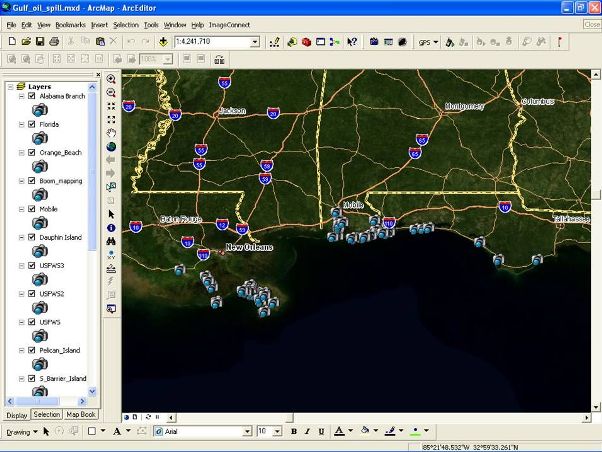
THORNTON, Colorado, USA, 21 September 2010 – Thousands of GPS-stamped photos showing the locations of sensitive habitats and wildlife impacted by the oil spill in the Gulf have helped decision makers determine where to deploy clean-up crews. These ‘geotagged’ photos are served out via the web to multiple Emergency Operations Centers (EOC) using photo mapping software and geographic information system (GIS) technology.
Emergency response personnel are using a variety of GPS cameras, like the Ricoh 500SE, to photograph natural areas impacted by the spill. Photos have even been taken by concerned citizens equipped with GPS-enabled cell phone cameras. The photos are uploaded to a map-based website to keep decision makers informed throughout the Gulf of Mexico region.

The ESRI map server website uses GPS-Photo Link, a photo mapping software solution developed by GeoSpatial Experts of Thornton, Colo. This software, which is capable of handling photos from nearly any digital camera and GPS receiver regardless of whether the two devices are directly integrated, automatically correlates the photographs with their GPS location coordinates. The software then outputs the merged information as a map layer in the GIS. The onscreen map icons, which denote the location of each photo, can be clicked to view the full photographic image.
“The GIS map server enables decision makers to visualize oil inundation trends along the coast by seeing the worst instances of beach and wildlife exposure to the oil,” said Tom Patterson of ESRI Inc., in Redlands, Calif.
Officials in the Gulf Region have published the geotagged photos on several map servers including the Virtual USA site operated by the Department of Homeland Security.
GeoSpatial Experts President Rick Bobbitt confirmed that disaster response is a growing application for geotagged photographs and photo mapping software. The firm’s GPS-Photo Link package, which was the first photo-mapping software when it was introduced in 2001, has been integrated into the curriculum at the National Spill Control School in Texas.
GPS-Photo Link software has been used extensively throughout the Gulf clean-up efforts by a variety of private-sector companies and government agencies. Florida Fish & Wildlife personnel were among those who used GPS-enabled cameras to collect photos of the slick from aircraft over the Gulf.
“Geotagged photos are ideal for documenting rapidly changing conditions relating to a flood, fire or spill,” said Bobbitt. “In minutes, the photos can be emailed to an EOC, processed in GPS-Photo Link, and output to a web-accessible GIS viewer like ArcView or online mapping site, such as Google Earth or Bing Maps.”
Geotagged photos have become so popular for visually gathering geographic information in business and governmental applications that photographic equipment manufacturers Ricoh, Nikon and Sony as well as some cell phone developers have introduced cameras with integrated GPS. GeoSpatial Experts has bundled its GPS-Photo Link software with a variety of these products, Bobbitt said.
contact:
Stephanie Giard
GeoSpatial Experts
Phone: 303.255.2908
Email: Stephanie@geospatialexperts.com


